EARS | Marine Band Radio
£400 + VAT TOTAL £480
including 1st class delivery
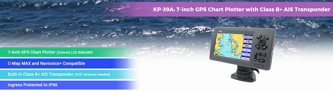
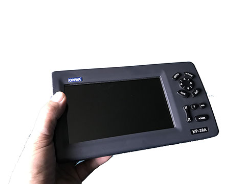
7 INCH GPS CHART PLOTTER WITH CLASS B AIS TRANSPONDER
The KP-39A by ONWA is a GPS Chart Plotter with:
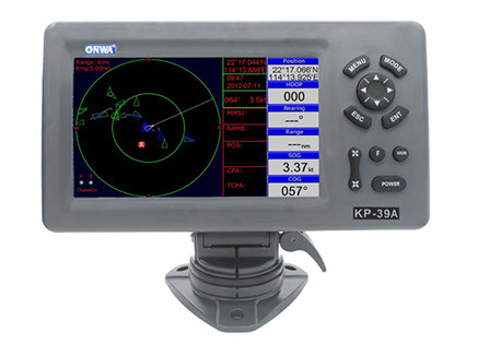
7″ Colour Display
Built-in Class B AIS Transponder
Free pre-programmed K-Charts
GPS and AIS functions in one compact housing - with easy to use controls and adjustable mounting
.jpg?crc=291547057)

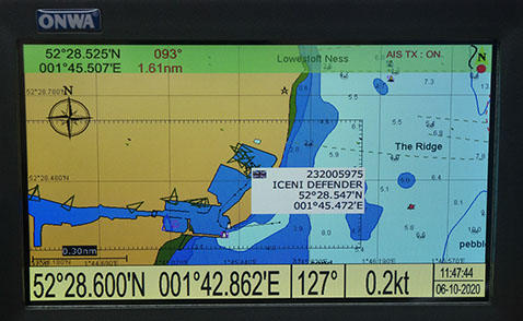
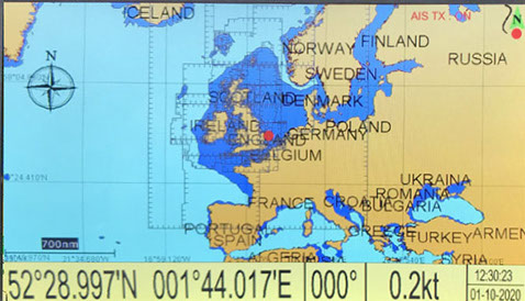
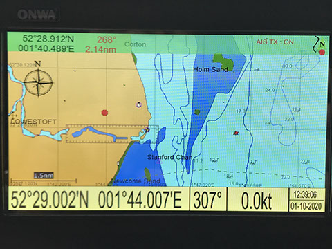
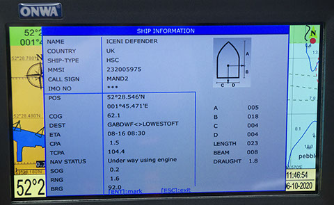
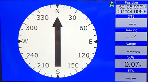
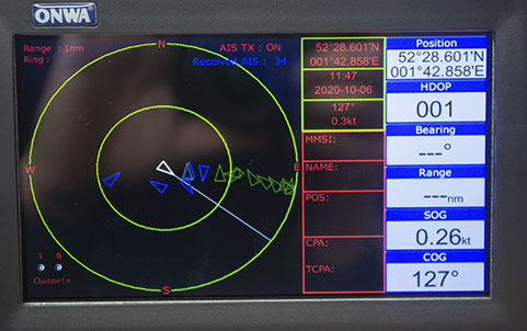
REAL SCREENSHOTS OF DISPLAY
AIS Characteristics
Frequency Rate
156.025 MHz~162.025 MHz
Access Scheme
SOTDMA
Channel Bandwidth
25 KHz
Modulation
GMSK
Data Rate
9,600 bps
Number of AIS Transmitter
1
Number of AIS Receiver
2
AIS Channel 1
CH 87B (161.975 MHz)
AIS Channel 2
CH 88B (162.025 MHz)
Tx Power Output
>5 Watt (37 dBm ± 1.5 dB)
RX Sensitivity
<-107 dBm @ 20% PER
RX Message Format
AIS Class A and B messages
Comply Standard
IEC-62287 IEC 62287-2 Ed. 2.0:2017
Power Supply
10.5 to 30VDC, current drain 1.5A at 12V
If you have a small boat, you probably have your VHF radio licence and without doubt, these devices are the next thing to add to improve your safety.
We have the smaller model from Matsutek, and these Onwa 7" units also have the facility to overlay a chart and a reference map is supplied to get you going. More detailed and up to date maps can be downloaded from many sources on the net if you need critical data.
These are very simple, offer lots of possibilities for the professional and amateur mariner and are quite easy to install, just needing a power supply from your boat and the connection of the supplied GPS antenna and a normal VHF marine band antenna - available from many chandlers and internet sources to match your boat. The large display makes navigation much safer and collision avoidance easier to assess and take action.
The full specification is at the end of the page.
For those unaware of them - here's a summary. They are small devices that contain a GPS receiver and with the supplied GPS antenna, know exactly where they are. They also have a built in VHF transponder which uses two of the channels we don't use for voice to broadcast your boats status. If you fully programme the unit it will send your MMSI, Callsign, Type of craft - from leisurecraft to tanker, and your current location and other GPS information. Other craft in the local area will receive this and you appear on their display. Their information is on your display. At the simplest - you can see on a radar-like display all the vessels within range. If you wish you can enter in warnings so that the device will alert you when there is a potential conflict - two courses crossing. It will show your heading and speed once underway, and is a huge aid to safety, making you visible to others, and equally making you aware of the locations of the other local vessels.
The built-in map shows coastal features and depths, plus navigation aids. Inland waterways are also displayed and assist navigation.
They are really your car GPS, but with all the other users displayed - incredibly useful. They come in various prices, sizes and features up to TV set size versions that can have maps displayed. This version has a modest footprint and easy to read display. It does have some very useful safety features - MOB - man over board being very handy in an accident situation - it grabs the exact position when you press the button so you can easily provide it in your Mayday message. Hit the MOB button and the exact point is displayed. Waypoints to help you plan can be stored - 12,000 are available and it will also store routes and tracks.
IS IT EASY TO SETUP?
Yes - you need to supply it with DC power (cable supplied) and install the small magnetic GPS antenna. To be able to receive and send AIS information, you need to source a new VHF antenna. These are available in the usual marine fibreglass style from a number of suppliers including Ebay and Amazon. The unit has an SO239 socket, so requires a PL259 type connector.
To set up, apply power and connect the two antennas. The range of the other vessel indicators depends on the height and performance of the extra VHF antenna. Some of the images here were taken some distance from the sea and with a low antenna height the other vessels are not in range.
All you have to do is add your own information that gets sent to others - including your vessel size. A handy little diagram assists you enter the right figures for length and beam etc.
You get the full package with the exception of a VHF antenna which you need to choose to fit your boat. These are available from around £40 via Google.
I'm pricing these at £480, and supplies are limited until the next delivery. I'll dispatch via 1st Class signed for or UPS which is currently very speedy.
REMEMBER - like VHF radios, you can only insert your MMSI number once, and it needs to be added to your licence. They do work unprogrammed and you will see the other vessels, but they will not know who you are - so register your MMSI if you can when it arrives.
Waypoints/icons
12,000 user waypoints with name, symbol,
3 system waypoints: MOB,Start,cursor
10 proximity waypoints
Routes
30 routes waypoint up to 170 points each,
plus MOB and Track Navigation or Goto Track modes
Tracks
8,000 points automatic track log;
10 saved tracks (up to 8000 track points each)
lets you retrace your path in both directions
Alarms
XTE, Anchor drag, arrival, speed, voltage, proximity waypoint,
Timer and AIS (CPA and TCPA) alarm
Drawing
1000 Drawing Marks; 2000 Drawing Lines (40 points each);
1000 Drawing Place Name; 8 colors for Drawing
Pallete
Normal
Daylight exposed to sunlight
Night in dark environment
NOAA paperchart colors
Tides
Built-in Worldwide Tide Data
Position Format
Lat/Lon
Basemap
Worldwide
External Map
Compatible with K-Chart 2.0, K-Chart 3.0, C-Map Max and Navionics+
User Data Storage
Internal backup of user settings or external SD-card
Plot Interval
5secs to 60 mins or 0.01 to 10nm
Plotting Scales
0.001 to 700nm
AIS
700 targets display
AIS Target Tracking
1000 Automatically saved tracks (100 points each)
10 Manually saved tracks (300 points each)
Perspective view
On/off (available for C-Map only)
Celestial
Sunrise/Sunset Moonrise/Moonset
GPS Receiver Characteristics
Receiver
50 parallel channel GNSS receiver continuously tracks and
uses up to 50 satellites to compute and update your position
Acquisition time
Cold start: 29 seconds
Hot start: 1 second
Update rate
1 second
Accuracy
Position:3 meters(95%) without S/A
Velocity: 0.1 meter/sec without S/A
SBAS
Supported
Satellite System
GPS and Beidou
Dynamics
Altitude: 18,000 m
Velocity: 515 m/s
Datum
WGS 84 & user defined
Antenna
GPS Patch Antenna
GPS Interface
GSP Data
RS232 input/output, NMEA 0183 V3.01 and V4.11
GPS Input Baudrate
Auto Scan (4800, 9600, 19200 and 38400)
GPS Output Baudrate
Selectable among 4800, 9600, 19200 and 38400
AIS Interface
AIS Data
RS232 output VDO, VDM, GGA, GSA, GSV and VTG
AIS Output Baudrate
38,400
PHYSICAL
Size
187mm(H)X250.1mm(W)X88mm(D)
Weight
1.03 kg
Display
7-inch Color TFT dayview LCD, 800×480 pixels
Waterproofing
Display unit: IP66
Antenna unit: IP66
Temperature range
Display unit: -15℃ to +55℃
Antenna unit: -25℃ to +70℃
Equipment List
Display unit
Quick manual
GPS Patch Antenna with 4m cable (SMA connector)
Mounting Brackets
Standard accessories pack
NMEA Sentence Supported
INPUT
(Auto scan Baudrate)
GGA, GLL, GSA, GSV, RMC, HDG, HDM, HDT
VTG, ZDA, MTW, VWR, VWT, MWD, VPW, VHW
TLL, TTM, VDO, VDM, GNS, MTA
RMA, DBT, DPT, MWV, BWC, XTE, ZDL, WPL, AAM,
APB, BOD, RMB, DSC, MDA, RPM, XDR
OUTPUT
Baudrate: Selectable 4800, 9600, 19200, 38400
GGA, GLL, RMC, GSA, GSV, AAM, APA
APB, BOD, BWC, BWR, DBT, DPT, HDT
MTW, RMB, TLL, VTG, WPL, XTE, ZDA
ZTG, ZDL, MWD, VPW, VWR, VWT
OUTPUT for Autopilot
APA, APB, BOD, XTE
Need Support?
If you think radios could help you - call us for advice - it's free!
01502 568021 01502 218989
Click here for our video and audio production website
East Anglian Radio Services
40 Bridge Road
Oulton Broad
Lowestoft
NR32 3LR
01502568021 - 07885039092
East Anglian Radio Services.

LATEST PRODUCT
-- GPS fitted marine mobiles
-- Waterproof hand held with GPS
-- Simple, waterproof hi power hand held
-- vehicle VHF and UHF radios
-- Event Radio Hire
-- Emergency Radios
-- End of line bargains
-- Second hand sales
-- Training and Advice
LATEST NEWS
Community repeater and radio hire available
Short and long term radio hire
Marine, Commercial and Amateur equipment available
2 and 4 wire intercom interfaces
BUSINESS HOURS
Tel: 01502 572136
40 Bridge Rd, Oulton Broad NR32 3LR
Monday-Friday: 9am to 6pm
Saturday: 10am to 1pm
Sunday: Closed
Out of hours by arrangement
Facebook - earsmedia
eastanglianradio@gmail.com
Copyright 2024 All Rights Reserved
EARS